
SÃO LUIS-MARANHÃO-BRAZIL
São Luís is a city in northeastern Brazil, on the island of São Luís, in the Atlantic Ocean. In the historic center of the city is the neighborhood of Praia Grande, in the area surrounding Rua de Portugal, marked by colonial buildings with distinctive tiles and cast iron balconies. The Palace of Lions, where does the state governor reside, displays French art and furniture. Nearby, you will find the great La Ravardière Palace, 17th century.
São Luís (often called São Luís do Maranhão) is a Brazilian municipality and the capital of the state of Maranhão. It is the only Brazilian city founded by the French, no dia 8 September 1612, later invaded by the Dutch and finally colonized by the Portuguese. It is located on the island of Upaon-Açu in the South Atlantic, between São Marcos and São José de Ribamar bays, in Golfão Maranhense. Em 1621 when Brazil was divided into two administrative units - State of Maranhão and State of Brazil - São Luís was the capital of the first administrative unit. No year of 1997 the historic city center was declared a cultural heritage site by UNESCO.
With an estimated population of 1 101 884 habitantes, São Luís is the most populous municipality in Maranhão and the fourth in the Northeast Region. Its area is 831,7 km², of that total 283 km² are in urban perimeter (12Th largest urban area in the country). The municipality is the seat of the Planning Region of the Maranhão Island (composed of 4 municipalities located on the island of Upaon-Açu) and the São Luís Metropolitan Region composed of 13 municipalities totaling 1.633.117 habitantes. The Human Development Index (IDH) from São Luís, according to United Nations data from the year 2010, it's from 0,768 above the Brazilian average, the 3rd best HDI among the capitals of the Northeast region of Brazil, and 4th among all 1.794 municipalities in the region.
The capital of Maranhão has a strong industrial sector due to large corporations and companies from different areas that settled in the city due to its privileged geographical position between the North and Northeast regions of the country. Its coastline strategically located much closer to major importing centers for Brazilian products such as Europe and the United States, allows fuel savings and reduced delivery time for goods from Brazil through the Port of Itaqui, which is the second deepest in the world and one of the busiest and most structured for foreign trade in the country.
The city is connected to the interior of the state and the state of Piauí by the São Luís-Teresina railway, as well as neighboring states Pará and Tocantins through the Estrada de Ferro Carajás and Norte-Sul railroads, the latter connects the city to the Midwest region, which facilitates and lowers agricultural flow from the interior of the country to the port of Itaqui. By highway, the capital of Maranhão is served by BR-135 (duplicate) that connects the island to the mainland, and by air transport has Marechal Cunha Machado International Airport, able to meet 5.900.000 passengers per year.[17] There is also a ferry-boats, carrying out the São Luís-Alcântara Crossing.
Etymology
The name of the city is a tribute given by the French to the king of France Louis XIII, as recorded by the chronicler of Equinocial France Capuchin Claude D’Abbeville. Later the name started to refer to Louis IX, called “São Luís King of France”. King Louis IX became popular because he died in a Crusade in the Middle Ages, later being canonized by the Church.
História
The capital of Maranhão, remembered today by the huge houses of Portuguese architecture, at first it housed only hollow wood and straw and an almost untouched landscape. On here, was the village of Upaon-Açu, where the Tupinambás Indians – between 200 and 600, second french chroniclers – lived on subsistence agriculture (small cassava and sweet potato plantations) and nature's offerings, hunting, fishing and collecting fruits.[19] Around the current city of São Luís, inhabited the indigenous ethnicity of the potiguaras.[20]
Prehistory
Even before the French arrived, the place where the city of São Luís is located today was already densely inhabited by indigenous peoples. Atualmente, researchers are looking for archaeological objects probably buried in the Sambaqui do Bacanga, located at Bacanga State Park. Researchers created trenches looking for traces of new artifacts that could have belonged to prehistoric populations. They also want to know the socio-cultural profile of the humans who inhabited this region. These objects probably belonged to prehistoric fisherman-gatherer-hunter-potter populations who lived in Bacanga sambaqui. The discovery could be very important, because it is believed that the populations that lived in the Amazon migrated to the Northeast Region of Brazil.[21] The Sambaqui do Bacanga is located in the North of Maranhão, in the central-west region of the island of São Luís. Your geographic coordinates:.[21]
Portuguese colonization
Em 1535, the division of Brazil by the Portuguese into hereditary captaincies gave, to treasurer João de Barros, the first opportunity for European colonization in the region. In the 1650, the city of Nazaré was founded, probably where today is São Luís, that ended, However, being abandoned due to the resistance of the Indians and the difficulty of access to the island.[19]
I know, since the end of the 17th century, new elements of European civilization already arrived in São Luís by sea (with emphasis on Carmelite religious, Jesuits and Franciscans, who also started to educate the population), this modernization process has increased in the new economic cycle, bringing urban benefits to the city. During the Pombaline period (1755-1777), canalization of the water and sewage network and the construction of fountains throughout the city.[22]
The lords' children were sent to study abroad, While, on the outskirts of the city, away from the repression of the police and elites, slaves fermented one of the richest black cultures in the country. Among wealthy merchant families, was Mrs. Ana Jansen,[23] known for mistreating, torture and even kill your slaves.
In addition to naming a lagoon in the new part of the city, Ana Jansen is also remembered through a legend: your carriage, pulled by headless white horses, would still be circulating today through the dark streets of São Luís.[24]
French occupation

Louis IX of France, depicted in El Greco's painting
Daniel de La Touche,[25][26] known as Lord of La Ravardière, accompanied by about 500 men from the French cities of Cancale, Granville and Saint-Malo,[27] arrived in the region in 1612 to found Equinocial France and fulfill the French dream of settling in the tropics. A mass said by Capuchins and the construction of a fort named Saint Louis (“São Luís”), in honor of Louis IX patron of France, and the French king of the time Louis XIII,[28] marked the founding date of the new city: 8 of September. Soon they allied themselves with the Indians, who were faithful companions in the battle against Portuguese people from Pernambuco determined to regain the territory, what happened a few years later.[29][30]
In November 1614, the Portuguese defeated the French at the Battle of Guaxenduba, in São José Bay. Em 1615, the troops of the Captaincy of Pernambuco commanded by Alexandre de Moura expelled the French from Maranhão, and the Olinda military Jerônimo de Albuquerque was assigned to command the city.[31] Azoreans arrived in São Luís in 1620 and the planting of sugar cane for the production of sugar and brandy has become, So, the main economic activity in the region. The Indians were used as labor in the fields. Production was small throughout the 17th century and as, practically, there was no money circulating in the region, the surpluses were exchanged for products from Pará, Amazon and Portugal. Cloth rolls were one of the objects valued at the time, even appearing in the wills of the wealthiest lords.[29][30]
Dutch occupation

São Luís do Maranhão on a map of 1629 by Albernaz I
Around 1641, landed, in Sao Luis, a Dutch fleet[32] formed by 18 vessels, with more than a thousand military personnel, under the command of Admiral Jan Cornelisz Lichthart and Colonel Koin Handerson. The main objective of the Dutch would be the expansion of the sugar industry in the region. Before the invasion in São Luís, the Dutch had already invaded much of northeastern Brazil and taken other cities like Salvador, Recife and Olinda.[32]
The Dutch invested against São Luís, scared the residents which made the city deserted. The Portuguese governor, the Portuguese nobleman Bento Maciel Parente, was taken prisoner and the Dutch flag was also raised. The whole city was ransacked, temple churches were stolen, about five thousand sugar arrobas were stolen. This all resulted in a paralysis of the economy of Maranhão. The captaincy's production was based on the commercialization of tobacco, carnation, cotton, brandy, sugar, sal, olive oil, leather, cassava flour, vanilla among other products.[32]
After the expansion of the Dutch to the interior beyond the island of São Luís, went in search of control over other maranhenses mills. The Portuguese were dissatisfied, so they started in 1642 the movements of revolt and mobilization to try to expel the Dutch from the lands of Maranhão. Started, So, a guerrilla that lasted about three years and that, in consequence, caused the destruction of the city of São Luís. Finally, after a violent battle that led to the death of many people, em 1644 the Dutch left the city of São Luís.
Economic expansion
The creation of the Companhia do Comércio do Maranhão, em 1682, integrated the region to the great commercial system maintained by Portugal. Sugarcane plantations, cocoa and tobacco were, now, export-oriented, making the purchase of African slaves viable, most of them from the region of present-day Guinea-Bissau.[35] The company, privately managed, started to manage business in the region, replacing the City Council. The high price fixed for imported products and disagreements regarding the production model generated internal conflicts in the elite that culminated in the Beckman Revolt,[36] considered the first colony uprising against Portugal. The movement was promptly suppressed by government forces.
In the second half of the 18th century, due to the War of Independence, the United States interrupts its cotton production and makes room for Maranhão to start supplying the raw material demanded by England.[37] Em 1755, General Company of Commerce of Grão-Pará and Maranhão is founded[38] and the port of São Luís gains enormous movement of arrival and departure of products. With the ban on the use of indigenous slaves and the increase in plantations, the number of black slaves goes up a lot.
São Luís in 1931.
Em 1780, Praça do Comércio was built,[39] in Praia Grande, which became the center of the economic and cultural upheaval in São Luís. Fabrics, furniture, books and food products, like Portuguese olive oil and beer from England, were some of the news from the old continent.
The commercial flow of cotton declined at the end of the 19th century, due to the recovery of American production and the abolition of slavery. Agricultural production was, slowly, being supplanted by the textile industry that, besides raw material, found labor and consumer market in the region. The new activity contributed to the geographic expansion of the city and the emergence of new neighborhoods on the periphery.
With the decline of the textile industry, São Luís was isolated from the rest of the country, only recovering after the first half of the 20th century, with the application of large investments, such as the construction of the Carajás Railway and the ports of Itaqui and Ponta da Madeira. The latter, owned by Vale, is the second deepest port terminal in the world and can handle ships that have a draft of more than 20 meter.
Geography
The municipality of São Luís occupies an area of 834,785 km²[and occupies an area that represents 0,2492 percent of the state of Maranhão, 0.0532 % of the Northeast Region[40] and 0.0097 % national territory.[40] Urban perimeter of 96,27 % and rural 3,73 %. 2nd south of Ecuador, in the geographical coordinates latitude S 2º31´ longitude W 44º16, being at 24 meters above sea level. Second this Census 2010, the young population reached 63,87 Percent (555 709 habitantes) under the age of 29 anos, highlighting that 375 624 (40,17 Percent) under 19 anos.
According to the regional division in force since 2017, instituted by IBGE,[41] the municipality belongs to the São Luís Intermediate and Immediate Geographic Regions.[2] Until then, with the validity of the divisions in microregions and mesoregions, was part of the São Luís Urban Agglomeration microregion, which in turn was included in the northern Maranhense mesoregion.[42]
The municipality occupies more than half of the island (57 Percent) and, according to records of the National Health Foundation (1996), the population is distributed in an urban center with 122 neighborhoods (that make up the semi-urban region) and 122 populated (that form the countryside). The city is divided into 15 tax sectors and 233 neighborhoods, subdivisions and housing estates.
Metropolitan region
It is limited to the municipality of São José de Ribamar and the Atlantic Ocean, separated from the mainland by the Mosquito Strait. Although they are also located on the island and are part of the metropolitan region, the municipalities of Paço do Lumiar and Raposa do not border São Luís.[43] It is the most populous city in the entire state. It is located on the island of Upaon-açu (indigenous word which means “Big Island”) with area 1 455,1 km² containing other municipalities: São José de Ribamar, with area 436,1 km², Paço do Lumiar, with area 121,4 km² and Raposa, with area 63,9 km².[44]
There are other islands located in the municipality of São Luís. Are they: [45] Tauá-Mirim, located between the Strait of Coqueiros and the Bay of São Marcos;[44][46] Tauá-Redondo,[44] located south of the island of Tauá-Mirim; Fear Island, located northwest of São Luís, close to Praia do Amor;[44] Two sisters[44], two islands located south of the island of Medo;[45] Pombinhas Island, located east of the island of Fear;[45] and Guarapirá, located in front of the Port of Itaqui, serving as a reference for access to the port.[45]
Weather
São Luís has a tropical climate, hot and humid. The minimum temperature for most of the year is between 22 and 24 degrees and the maximum usually between 30 and 34 degrees.[47] It presents two distinct periods: a rainy, from December to July, and another dry, from august to november. The rainfall average is 2200 mm / yes, concentrated between February and May. The months with the highest average rainfall are March and April, while the smallest are September and October.[48]
The first rains usually start to fall between late December and early January.. During these two months it is common for some days to be cloudy, others rainy and others sunny, thus characterizing the transition period between the drought and the rainy season. From February to May, the intertropical convergence zone is more active in the municipality and therefore the days of these months are marked by few or no periods of sunshine, strong storms, mild temperatures and sometimes fog in the morning, featuring the rainy season.
| Largest accumulated rainfall in 24 horas registered in São Luís for months (INMET, 1971-here I'm)[49] |
|||||
|---|---|---|---|---|---|
| Month | Accumulated | Data | Month | Accumulated | Data |
| Janeiro | 187,8 mm | 08/01/2011 | Julho | 85,1 mm | 01/07/1990 |
| Fevereiro | 210 mm | 06/02/1980 | Agosto | 45,8 mm | 04/08/2006 |
| Março | 234,4 mm | 24/03/2019 | Setembro | 62,8 mm | 15/09/1975 |
| Abril | 177,2 mm | 19/04/1974 | Outubro | 40 mm | 22/10/1973 |
| Maio | 181,6 mm | 11/05/2014 | Novembro | 159,2 mm | 30/11/2018 |
| Junho | 133 mm | 05/06/2008 | Dezembro | 159,7 mm | 28/12/1993 |
June and July are also transition months, but from the rainy season to the drought. This period is characterized by rainy days, others with strong sun, low heat and humidity and others with muggy weather, no winds and very cloudy, popularly known as lull. On rare occasions, it is also in this period of transition that waterspouts form pela along the seafront. A peculiar characteristic of the rains of June and July in São Luís is because they are very intense, sudden and fast (normally not exceeding 30 minutos) and usually accompanied by a lot of wind. After this transition period, the drought period comes, which corresponds from August to November. During this period the days are sunny and with high temperatures, the rains decrease dramatically, the humidity in the afternoon drops to until 40% and the winds get stronger getting to 50 km / h, mainly between the months of September and October, contributing to the appearance of fire outbreaks.
According to data from the National Institute of Meteorology (INMET), desde 1971 the lowest temperature recorded in São Luís was 17,9 ° C baby 26 de março de 1987.[50] Minimum temperatures below 20 ° C also occurred in 5 de julho de 1974 (18,1 °C), 4 de julho de 1974 (18,2 °C), 13 de março de 1987 (18,9 °C, 12 de março de 1987 (19 ° C e 3 de julho de 1974 (19,5 °C).[50] The absolute maximum reached 37,2 ° C baby 4 de outubro de 1997.[51] The largest accumulated rainfall in 24 hours reached 234,4 millimeters (mm) em 24 de março de 2019, breaking the previous record of 210 mm em 6 February 1980. [49] The monthly rainfall record is 849,2 mm in April 1985.[52]
| [To hide]Climate data for São Luís | |||||||||||||
|---|---|---|---|---|---|---|---|---|---|---|---|---|---|
| Month | Jan | Feb | Mar | Apr | May | Jun | Jul | Ago | Set | Out | Nov | Ten | Year |
| Record maximum temperature (°C) | 34,7 | 35,4 | 34,5 | 34,4 | 34,6 | 33,9 | 34,1 | 35,5 | 35,4 | 37,2 | 35,2 | 35 | 37,2 |
| Average maximum temperature (°C) | 30,6 | 30,2 | 29,9 | 30,2 | 30,9 | 31,1 | 31 | 31,4 | 31,7 | 31,9 | 32,1 | 31,8 | 31,1 |
| Compensated average temperature (°C) | 26,7 | 26,4 | 26,1 | 26,2 | 26,6 | 26,4 | 26,2 | 26,5 | 26,9 | 27,2 | 27,5 | 27,4 | 26,7 |
| Average minimum temperature (°C) | 23,9 | 23,6 | 23,4 | 23,4 | 23,6 | 23,2 | 23 | 23,3 | 23,9 | 24,2 | 24,6 | 24,5 | 23,7 |
| Record minimum temperature (°C) | 20 | 20,1 | 17,9 | 21,1 | 20,2 | 20,6 | 18,1 | 20,3 | 21 | 21,2 | 21,6 | 20 | 17,9 |
| Precipitation (mm) | 226,4 | 321,4 | 462,1 | 457,6 | 302 | 183,4 | 122,9 | 30 | 6,4 | 4,7 | 10,5 | 72,6 | 2 200 |
| Precipitation days (≥ 1 mm) | 13 | 16 | 22 | 21 | 18 | 14 | 10 | 4 | 1 | 1 | 1 | 4 | 125 |
| Compensated relative humidity (%) | 83,4 | 85,8 | 87,6 | 88,6 | 86,7 | 84,9 | 84,5 | 81,3 | 78,3 | 76,8 | 76,7 | 78,4 | 82,8 |
| Hours of sun | 155,1 | 119,5 | 111,5 | 116,5 | 163,2 | 204,5 | 235,9 | 265,5 | 257,2 | 259,2 | 238,2 | 212,2 | 2 338,5 |
| Fonte: National Institute of Meteorology (INMET) (climatological normal of 1981-2010;[48] temperature records: 1971-here I'm)[50][51] | |||||||||||||
Relief and hydrography
The capital of Maranhão is at an altitude of four meters above sea level. There are wetlands, extensive beaches, mangroves and dunes that form the coastal plain.[53] The São Luís basin is composed of sedimentary rocks formed in the Cenozoic era and has several types of minerals, limestone is one found in abundance.[54]
The main rivers that run through São Luís are Bacanga, running through Bacanga State Park,[55][56] and Anil, that divides the modern city and the historic center. The Itapecuru River supplies[57] the city, although it does not pass the island.
The hydrography of the region is formed by the rivers of Anil, Bacanga, Tibiri, Patience, Maracana, Pebble, chili, Coconut and Dogs. They are small rivers that flow in different directions covering dunes and beaches. Since the Anil River with 12.63 km long, and Bacanga with 233,84 km flow to São Marcos Bay having mangrove-covered areas in their estuaries.[58]
To the lagoon of Jansen[59] (laguna, because there are exits to the sea) is the main and largest lagoon on the island, with six thousand square meters of area.[59]
Beaches
Ponta D’Areia Beach

Monument to the Fishermen, on São Marcos beach

Sunset at Praia do Calhau
The beaches are one of the most popular tourist spots for tourists visiting the city. Stand out:
- Guia Beach: weekend of lots of sun and leisure in the Itaqui Bacanga area. Hundreds of people take advantage of the sunny Sunday to sunbathe and cool off on the beaches on the waterfront of the Itaqui Bacanga axis.
At Praia da Guia, one of the best known and most visited beaches in the region, the movement is intense early in the morning. Bathers and street vendors crossed the canal in canoes to finally reach one of the most beautiful beaches in the capital.
- little beach: Another popular place is Prainha, which is on the right side of Praia da Guia, following after the Bonfim community. Prainha is very cozy and has bars and restaurants. One of the unique attractions of Prainha is the view of São Luís. Located across the Campos Melo Ramp, the visitor has a view of the entire city, of the Palace of Lions, Mercês Convent and the entire Historic Center. Many are enchanted by the panoramic view of downtown São Luis. The view of the city is wonderful from this angle. It is close to the center, you can see San Francisco and the whole new city.
- Cajueiro Beach: The cashew beach,is in the neighborhood of the same name in the countryside of the city, close to Vila Maranhão,in the Itaqui-Bacanga area. The beach is deserted and surrounded by nature and it is from there that the residents of the community get their daily livelihood. Access is via BR-135, following the road that gives access to the neighborhood and the beach.
- Praia do Amor: The Beach of Love, located in Marinha area, access is already more difficult. Far, approximately, six kilometers from the neighborhood Anjo da Guarda, the way is also by BR-135, following the road that leads to Ponta da Espera.
- Ponta d’Areia beach: is the most visited by the population and tourists, due to easy access. It is just three kilometers from the city center. On this beach, Ponta D’Areia Coastal Espigão was built, built to protect the coast from the action of ocean waves, but that has become an important tourist and leisure spot in the capital.[60][61]
- São Marcos Beach: stands out for its strong waves, and is very popular with surfers.[60]
- Calhau Beach: is one of the best known beaches in the capital of Maranhão. It has weak waves and dunes covered by vegetation.[60]
- Olho d’Água Beach: is located at 13 kilometers from the city center. It is surrounded by dunes and undergrowth.[60]
- Praia do Meio: located between the beaches of Olho d’Água and Araçagi, has clear waters suitable for kitesurfing.[62]
With the exception of some stretches of Araçagi beach, no other – Ponta d'Areia, Pebble, São Marcos and Olho d’Água – is in a condition to bathe. In June 2009 beaches that were unsuitable for bathing were marked with warning signs, warning bathers about the condition of the water quality in each stretch.[63][64]
Fauna and Flora
Bacanga State Park
The city of São Luís is located in an area where two floras meet: the flora of the amazon and the northeastern flora. This makes the island of São Luís have a very diverse flora and rich in species. In the coastal region of the city (comprising almost all of it) have been cataloged 260 plant species entered into 76 families and the fabaceae family (legumes) has the largest number of species, are more than 26 listed. Among all surveyed regions in Brazil, 125 species are exclusive to São Luís.[65]
The city's vegetation is diverse and, for the most part, coastal. With large number of coconut trees, São Luís also has a considerable amount of mangroves. The municipality's original vegetation cover is a mix of broadleaved forest, babassu, dune vegetation, sandbank and mangrove. Environmental parks are found throughout the capital of Maranhão, among which the Bacanga State Park, Environmental Protection Area of the Maracanã Region, the Itapiracó Environmental Protection Area and the Sítio do Rangedor State Park, among others, that hold remnants of vegetation from the Amazon rainforest.[66]
A recent survey (2007) proved the existence of more than 28 Phlebotomine species, which are mosquitoes that transmit Leishmaniasis in the metropolitan region of São Luís, mainly in areas of environmental preservation. With the disorderly occupation of the population in the region, outbreaks of leishmaniasis may occur in the population.[66]
In the São Luís Botanical Park there are many species of vegetables and some animals such as the sloth, Capuchin monkey, the Capuchin Monkey, the Maracajá Cat, the Box, the Tatupeba, Paca and Tamanduá-mirim.[67]
The protected areas of the São Luís region were mapped by geoprocessing satellites (Ikonos Satellite Image - 0,5 cm) and there are a total of seven divided into: Bom Menino Park, Diamond Park, Rio das Bicas Park, Itaqui / Bacanga Environmental and Recreational Park and Sacavém Forest Reserve Zone.[68]
The Lagoa da Jansen State Park stands out for its infrastructure adapted to the practice of sports, containing a large number of bars and restaurants for all types and tastes.[59][69]
Demography
Religion

Cathedral of São Luís do Maranhão
No Census 2010 declared that 65,90% of the population is catholic; 23,61% is evangelical and 0,61% is a spiritist.[70]
The Cathedral of São Luís do Maranhão was erected by order of the third Captain-General Diogo Machado da Costa in 1629, when the city was experiencing a smallpox outbreak. It is a tribute to the Portuguese protector at the Battle of Guaxenduba (victory over the French). It was rebuilt several times until 1922, when it took on the neoclassical aspect. Inside, the main altar carved in gold stands out.[71]
Ethnic composition
Like the rest of Brazil, São Luís has, in its composition, European ancestry as Portuguese,Dutch and French,indigenous and african. According to a genetic study of 2005, the European contribution reaches 42 Percent; to indigenous, 39 Percent; and the african, 19 Percent.[72]
Politics

Palácio de La Ravardière, São Luís City Hall

Palace of the Lions, seat of the State Government
Political power in São Luís is represented by the São Luís City Hall, headed by the mayor, assisted by the deputy mayor and municipal secretaries. For the mayor to create some law, the approval of the Legislative Power is needed, this being composed by the São Luís City Council. Official symbols of the city are the coat of arms, the flag and the anthem.
The Palace La Ravardière,[73] seat of municipal government (town hall), was originally built around 1689, having been House of the Chamber and Jail. Symmetrical facade, on two floors, centered by a cannula, decorated with shell and stylized acanthus leaves, giving idea of small pediment, all stucco. Forward, stonework sidewalk displays bronze bust of Daniel de La Touche, Senhor de La Ravardière, sculpted by Bibiano Silva.[74]
The city is also the political and institutional seat of the Government of the State of Maranhão, the Palace of the Lions being the government headquarters building. The Palace, with origins in the fort that gave rise to the city in the 17th century, is one of the most important cultural symbols of the city.[75]. The Legislative Assembly of Maranhão is the legislative power organ of the state of Maranhão, exercised through state deputies.[76]
São Luís has the largest electoral college in the state of Maranhão, followed by Empress, Contact, Timon and Codó. Its total electorate is 668 817 voters in 2010. Belongs to the São Luís District.[77]
São Luís is the seat of the Maranhão Court of Justice,[78] founded on 1813. It is also the seat of the Regional Labor Court of the 16th Region (TRT), with jurisdiction over the State of Maranhão. Capital also hosts the Regional Electoral Court (THREE) [79] and State Court of Auditors,[80] that despite not belonging to the Judiciary, because it is constitutionally linked to the Legislative Branch, has administrative and financial autonomy. Its function is to assist the Legislative and oversee the application of public money. São Luís is also the headquarters of the Attorney General's Office, of the Attorney General's Office and the Section of the Brazilian Bar Association in Maranhão (OAB-MA).[81]
Subdivisions
Officially, São Luís is constituted by the headquarters district. It was divided into two districts until 1997: São Luís and Anil.[82] Sometimes São Luís is divided into Cidade Nova, which comprises the neighborhoods of the noble area like Renaissance, Ponta d'Areia, Pebble, among others, and Old Town with the Center, Monte Castelo, Anil and other neighborhoods, mostly middle class. The city is divided into 38 neighborhoods, but if you count on the subdivisions of the neighborhoods, stilts, shanty towns, come to 96 and in some cases, exceed more than 100 neighborhoods.[83]
Economia
Economic activities of São Luís – (2014)

Image of Avenida Colares Moreira

Ana Jansen Avenue
The economy of Maranhão was one of the most prosperous in the country until the middle of the 19th century.[84][85] However, after the end of the Civil War of the United States of America,[86] when it lost space in the export of cotton, the state collapsed;[84] only after the end of the 1960 in the 20th century the state began to receive incentives and left isolation, with rail and road connections with other regions.[87]

São Luís Historic Center
At the end of the 18th century, the increase in international demand for cotton to meet the British textile industry combined with the reduction of American production due to the United States War of Independence provided the ideal scenario for stimulating cotton production in Maranhão. Shipping companies Southampton & Maranham Company e Maranham Shipping Company, steam shipping, who transported cotton from the states of Georgia and Alabama, started operating on the São Luís - London axis, taking the production from Caxias and Baixada Maranhense. Until the beginning of the 20th century, São Luís still exported cotton to England by sea, through the Red Cross Line and Booth Line (whose route extended to Iquitos) and Liverpool-Maranham Shipping Company.[88]
In this period, the golden phase of Maranhão's economy, São Luís started to experience a cultural effervescence. The city, which was more related to European capitals than other Brazilian cities, was the first to receive an Italian opera company. It had pavement and lighting like few in the country. Weekly received the latest news from French literature. The large cotton fortunes and the local commercials sent their children to study in Recife, Salvador, Rio de Janeiro and, mainly, Europe.[88]
The opening of the Port of Itaqui,[89] in Sao Luis, currently the second in depth in the world,[89] second only to Rotterdam, In Holland,[89] and one of the busiest in the country, served to transport industrial and iron ore production by train from the Carajás Railway,[89] activity explored by Companhia Vale do Rio Doce. The strategic proximity to the European and North American markets made Porto an attractive export option, but suffers from greater coastal navigation.[89]
The Ponta da Madeira Maritime Terminal, private port belonging to Vale, adjacent to the Port of Itaqui, is mainly destined for the export of iron ore and handles more than 110 million tonnes of ore.[90]
It is possible to perceive the dimension of Vale in São Luís by analyzing the municipality's exports in 2012, which was mainly aluminum oxide (47,84%), iron ore (34,98%) and raw aluminum (10,67%).[91]
With the construction of the Maranhão Grain Terminal (tegris) at the port of Itaqui, the export capacity of grains such as soybeans was expanded, corn and rice, using the infrastructure of the Carajás Railway to transport production from the south of the state, as well as the states of Tocantins and Goiás, with the North South Railway. No year of 2017, the port moved around 6 million tons of soy.[92]
Ludovic's economy is based on the aluminum processing industry, food, tourism and services. São Luís has the highest GDP in the state,[93] hosting two public universities (UFMA and UEMA) and several teaching centers and private colleges. According to the latest data survey by the Brazilian Institute of Geography and Statistics, the city of São Luís has the gross domestic product of 26 326 087 000 real, being, assim, the 26th national economy among more than 5 560 Brazilian municipalities and occupying the 13th position among the capitals.[94]
Infrastructure
São Luís stands out in public lighting: 100 percent of the city is covered by lighting networks, the city has 50 percent of paved streets with availability of electricity services and 30 percent of streets have urban drainage. 79 percent of Ludovic households are served by the sewage supply network, 43 percent of the population has sanitary drains, 69 percent of households have garbage collected by cleaning services and there are 261 589 home phones installed in the city.[95] Data from 2000 indicate that São Luís had 202 231 households checked between homes, apartments and rooms. Of this total, 168 284 were own properties distributed among 746 607 residents.
São Luís also has many problems, like traffic jams, huge queues at terminals, among other problems.[96] With the great growth of the population, public transport is not being effective which brings great inconvenience to the population.[97]
Transportation

São Luís International Airport

Port of Itaqui
The municipality has five integration terminals (Big beach, Saint Cristopher, Cohab-Cohatrac, Cohama-Vinhais and Industrial District) that allow passengers to travel by bus all over the city and part of the metropolitan region by paying only one ticket. The SIT São Luís line network (São Luís Integrated Transport System) is based on two types: those that integrate the neighborhood-terminal and those that integrate the terminal into the city center or another terminal. They operate in the city, divided into four operational lots, three consortia and one company, that hold, jointly, a fleet of about 1 000 vehicles that use electronic ticketing systems. With the completion of the integration terminal project in the administration of Tadeu Palácio, the last phase of the reformulation of public transportation in São Luís began, the expansion of vehicle lines and fleet.[98][99]
The vehicle fleet in the capital of Maranhão (year data 2008) it's composed by 130.277 automobiles, 6.384 trucks, 416 tractor trucks, 19.388 pickup trucks, 1.056 micro bus, 42.806 motorcycles, 3.625 scooters, 2.827 bus and 14 tractors.[100] Road access to the city is via BR-135, across the Marcelino Machado bridge (one entry and one exit bridge), that connects the island to the mainland, over the Strait of Mosquitoes. Em 2018, the BR-135 was duplicated, in the stretch of Campo de Perizes, between São Luís and Bacabeira.[101] There is also the São Luís Bus Terminal for passengers.
São Luís International Airport has a terminal with capacity to serve 3,4 million passengers per year.[102] Located just 14 kilometers from the city center, offers passengers a restaurant, two snack bars and souvenir shops. It is served by three Brazilian airlines, blue, Latam, and Goal, with daily flights, from the main Brazilian capitals.[103]
In addition to transporting iron ore, Soy, fuels, among other products, the Carajás railway also transports passengers between São Luís and the cities of Marabá and Parauapebas, no stop. There is a junction between it and the North-South railway, in the municipality of Açailândia (MA). The São Luís-Teresina railway transports fuels, cement, pig iron and containers, with interchange with the Teresina-Fortaleza Railway, enabling interconnection between the ports of Itaqui (MA), Pecém (CE) and Mucuripe (CE).[104][105]

The São Luís – Alcântara crossing ferry
A system of ferry-boats performs the São Luís-Alcântara Crossing, crossing St. Mark's Bay, and shortening the distance between the capital and the Baixada Maranhense, carrying more than 1,8 million passengers per year.[18] The main ports of São Luís are the Port of Itaqui, Ponta da Madeira Terminal and Alumar Port, considered strategic due to the close location of European markets, North America and the Panama Canal (where it is possible to reach the countries of Asia more quickly), depth (up until 23 meter), rail access and infrastructure.[92] The Porto do Itaqui Thermoelectric Plant (360 MW), coal-fired, was built next to the port complex.
Cheers
The municipality of São Luís has three federal health establishments, 23 state, 70 municipal and 212 private (2011).[106] Among the city's hospitals, deserve to be highlighted (beyond the UPAs, UBS, and other types of health facilities):
- Public hospitals:
- Municipalities: Municipal Hospital Djalma Marques (First Aid I); Hospital Municipal Dr. Clementino Moura (First Aid II); Children's Hospital Dr. Odorico Amaral de Matos; Women's Hospital.[107]
- State: Maranhão Cancer Hospital –Tarquínio Lopes Filho; Hospital of Traumatology and Orthopedics of Maranhão (HTO); Nina Rodrigues Hospital; Presidente Vargas Hospital; Carlos Macieira Hospital; Aquiles Lisboa Hospital; Hospital Dr. Adelson de Sousa Lopes Vila Luizão; Maranhão Public Servants Hospital; Juvêncio Matos Children's Hospital (Ninar Support House).[108][109][110]
- Feds (HU-UFMA): University Hospital-Maternal and Child Unit; University Hospital-Presidente Dutra Unit.
Education and science

Federal University of Maranhão
The capital of Maranhão has a large number of public and private schools, universities and colleges, in addition to federal institutes. Data from 2008 of the Brazilian Institute of Geography and Statistics[111] show that the city of São Luís has 474[111] elementary schools, 400[111] preschools schools and 133[111] high school institutions.
The main educational institutions based in São Luís are the Federal University of Maranhão,[112] the State University of Maranhão,[113] the State Institute of Education, Maranhão Science and Technology[114] and the Federal Institute of Maranhão,[115] in addition to important private higher education institutions, such as the Maranhão University Center,[116] the São Luís College[117] the Faculdade Atenas Maranhense (FAME),[118] the Santa Terezinha College (HONOR),[119] the Faculty of Maranhão (FACAM),[120] the Institute of Higher Studies of Maranhão (JESUS),[121] the Vale do Acaraú University (UVA IDEM),[122] the UNISEB COC University Center[123] and the Getúlio Vargas Foundation (FGV)[124]
The Research Center for Natural History and Archeology of Maranhão, located in a historic townhouse, works in the fields of Paleontology, Arqueologia e Ethnologia, with knowledge-oriented actions, heritage appreciation and preservation.[125]
Media and communication
São Luís hosts the headquarters of the two largest communication groups in the state of Maranhão, the Mirante Group (responsible for TV Mirante São Luís in the city, Radio Mirante, Mirante FM and the newspaper The State of Maranhão) and the Communication Diffuser System (responsible for TV Difusora São Luís, Radio Diffuser and FM Diffuser). National groups also have companies in the municipality, as a state EBC (controls TV Brasil Maranhão) and Associated Diaries (control the newspapers The Impartial and Here Maranhão).
Culture
|
||||
|---|---|---|---|---|
| UNESCO World Heritage | ||||
|
|
||||
| Tiled facades of the Museum of Visual Arts in the Historic Center of São Luís.
|
||||
| country | ||||
| Criteria | iii, iv, v | |||
| Reference | 821 | |||
| Region** | Brasil | |||
| Coordinates | 2°30’51″S 44°18’09” W | |||
| Subscription history | ||||
| subscription | 1997 (? session) | |||
| * Name as inscribed on the World Heritage list. ** Region, according to classification by UNESCO. |
||||

São Luís has very strong manifestations like the bumba-meu-boi, party of Afro-indigenous tradition that emerges in the city during the celebrations of the month of June. Além disso, owns the Crioula Drum and Cacuriá. These events take place during the June festivities. No carnival, the tradition of São Luís is a strong street carnival, where popular blocks mix with players and traditional bands. The Drum of Mine, afro-brazilian religion, has at Casa Grande das Minas Jeje (Querebentã de Tói Zomadônu) and at the Nagô House (Nagon Abioton), founded in the 19th century, its most important terreiros.
Em 1 September 2010, São Luís was elected the thirteenth American Capital of Culture for the year 2012,[126][127] happening Quito, by Xavier Tudela. This is a cultural initiative, of cooperation and promotion in the countries of the Americas, respecting their national and regional diversity and highlighting their cultural heritage.[126]
The city was listed by the United Nations Education Organization, Science and Culture as a Cultural Heritage of Humanity, em 1997. It has a colonial architectural collection valued at around 3 500 buildings, spread over more than 220 hectares of Historic Center, most of them are terraces with viewpoints, many lined with precious Portuguese tiles. Several buildings have been restored; The city hall, for example, works at the La Ravardière Palace, construction of 1689.[128]
Ceprama works as an institution for disseminating the culture of Maranhão, with a permanent typical craft fair.[129]
Urban heritage
The Ribeirão Fountain was built in 1796 to supply the city, has the courtyard lined with stonework. Its barred windows give access to the underground galleries (old sewer networks) passing through the historic center.[130] The Fonte das Pedras served as a base for the army of Jerônimo de Albuquerque during the expulsion of the French founders in 1615. It is surrounded by trees and benches.[130]
Until the beginning of the construction of Porto do Itaqui in the 1960, was the main port of the city of São Luís. The Sagração Pier was built in the early 1990s. 1840 in masonry and in the original design, would go to the Convento das Mercês, but for lack of resources, was limited to where the Praia Grande pier is today. The pier extends to next to Maria Aragon Square.[131]
The Ponta d'Areia Coastal Spike, built to protect the coast from the action of ocean waves, has become an important tourist and leisure spot, in particular to watch the sunset.[132]
Literature

Academia Maranhense de Letras
At the end of the 18th century, the increase in international demand for cotton to meet the British textile industry coupled with the reduction in North American production due to the United States War of Independence provided the ideal scenario for stimulating cotton production in Maranhão. In this period, the golden phase of Maranhão's economy, São Luís started to experience a cultural effervescence. The city, which was more related to European capitals than other Brazilian cities, was the first to receive an Italian opera company. Weekly received the latest news from French literature.
Since then, São Luís came to be known for “Brazilian Athens”. The denomination stems from the number of local writers who played an important role in Brazilian literary movements from romanticism. Emerged, assim, the image of Maranhão as the state that speaks the best Portuguese in the country. Brazil's first grammar was written and edited in the city by Sotero dos Reis. Even today, the city still has a great natural vocation for literature and poetry.
Part of its cultural heritage is the wealth of poems and novels of its great writers, such as Aluísio de Azevedo, Gonçalves Dias, Grace Spider, among others, what made the city known as Atenas Maranhense.[133] In addition to the literature, cadenced rhythms overflow with joy and sensuality, through the creole drum,[134] reggae[135] and the bumba-meu-boi.[136]
theater
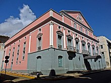
Arthur Azevedo Theater
The Artur Azevedo Theater, the second oldest in Brazil, was founded under the name of Teatro da União by two Portuguese traders in 1817. In the original design, the theater would extend to Largo do Carmo, but ended up being reduced by a Church veto. Based on the so-called Italian audience theater, horseshoe, Only in 1922 earned the current name. It worked as a cinema between 1940 and 1966 and, abandoned, ended in ruins.[137][138]
Em 1989, when only the original facade still resisted, was demolished and rebuilt according to the original design. Currently has the capacity to 750 spectators, spread over four floors. The shows are recorded by a professional video circuit installed in the theater and retransmitted by TV Senado.[137][138]
Museums

Solar Gomes de Sousa, headquarters of the Historical and Artistic Museum of Maranhão

Convent of Merces, headquarters of the Brazilian Republican Memory Foundation
The Museum of Visual Arts has a collection of colonial tiles, murals, photographs and works by artists from Maranhão. One of its highlights is the collection of prints by the writer Arthur Azevedo.[139][137][130]
Working at Solar Gomes de Sousa, the Historical and Artistic Museum of Maranhão was inaugurated in 1973 and stands out for the reconstitution of the typical decoration of the nineteenth century townhouses with furniture, objects and works of art.[140]
Convento das Mercês was built in 1654 and inaugurated by Father Antônio Vieira, where the headquarters of the former Convent of the Order of Mercedaries worked. Today it houses the Foundation of the Brazilian Republican Memory, that brings together unique works of the country's history, documents from the presidency of José Sarney, gifts offered by other presidents, in addition to a museum containing works of sacred art, paintings, sculptures, and a library.[141][142]
The Museum of Sacred Art works at the Episcopal Palace. Your collection, which belongs in part to the Archdiocese of São Luís, is composed of pieces from the 18th and 19th centuries in the Mare styles, rococo, baroque and neoclassical.[137][143]
Cafuá das Mercês or Museu do Negro is a small townhouse where the slave market that arrived in São Luís functioned, today it houses a reference museum of black culture, with pieces of art of African origin and musical instruments.[137][144][145]
The Maranhão Reggae Museum is the first thematic reggae museum outside Jamaica and the second in the world, and aims to materialize the memories of the Jamaican rhythm that conquered Maranhão.[146]
Cultural centers

Odylo Costa Filho Creativity Center, decorated during the June festivities
The Domingos Vieira Filho Popular Culture Center is located in a colonial townhouse of 3 floors, maintains a large collection of pieces from different cultural events (bumba-meu-boi, creole drum, carnaval, coconut dance etc) and religious (mine drum, Feast of the Divine etc) of State. In addition to this, has objects of indigenous culture and handicrafts.[147]
Considered the largest tiled building in the country (has three floors), Solar São Luís was built in the second half of the 19th century. Its interior was destroyed by fire and was abandoned until it was acquired and restored by Caixa Econômica Federal, who installed an agency in it.[148]
Casa do Tambor de Crioula is a space designed to preserve and disseminate this manifestation of popular culture.[149]
The Odylo Costa Filho Creativity Center is an old renovated warehouse, houses a cultural space with cinema, theater, art Gallery, courses and other activities.[150]
sports

Governador João Castelo Stadium
As in all of Brazil, football is the most practiced sport in the entire city of São Luís. Em 1981, Governador João Castelo Stadium was built, which is one of the largest stadiums in the entire Northeast Region. In season, the governor of Maranhão was João Castelo and in his honor put his name on the Stadium, which is also known as the Canhoteiro complex. em 2012 the stadium underwent extensive renovation and modernization that cost 28 million reais with the placement of AntiVandalism chairs, LED screens, 22 CCTV cameras, adaptation to people with special needs, air conditioning of Radio and TV booths, 75 new spotlights, among other improvements to adapt the stadium to FIFA's safety and structure requirements.
How 32 km of beach, sports like surfing, beach soccer, Stand Up Paddle, footvolley, Beach volleyball, frescobol and kitesurf are popular in São Luís. em 2016 Sampaio Correa Basquete gained national prominence by becoming champion of the Women's Basketball League.
The city has 3 major football clubs, Sampaio Corrêa founded in 1923 disputing the second division of Brazilian football, the Moto Club founded in 1937 that disputes the fourth national division, and Maranhão Atlético Clube founded in 1932 which also disputes the fourth national division. Respectively occupy the 39th positions, 66ª and 95ª in the National Club Ranking 2017.